Places, Earth
Southeast Arizona, 2026
Southeast Arizona, 2026
|
|
Places, Earth
Southeast Arizona, 2026 |
|
|
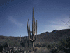
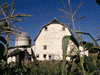
Day One: Tucson or Bust Originally scheduled for Christmas Day to New Years Day, we postponed it two weeks for health reasons. My wife said that a delay would work better for her, but she had a knee problem and told me to go without her. The car had been packed in the garage for over two weeks, so it wasn't hard to get off on time. I was on my way by 7:00 AM heading east. I skipped the first rest area near the San Bernardino/Riverside County line. To my left, a narrow column of black smoke poured out a an adjacent Starbucks, someone was having a bad day. A little before 9:00, I stopped at the rest area near Palm Springs. This rest area is surrounded by the first wind farm in the United States, and there was a cold wind. I had already decided to skip the third rest area, just as well, is was closed, leveled, undergoing a complete rebuild. Since the trip was originally scheduled for Christmas Day and the Epiphany was only a few days earlier, I played the three loaded Christmas CDs, then started the audiobook The Restaurant at the End of the Universe (second book in the Hitchhiker's Guide to the Galaxy series). At 10:45 / 11:45, I crossed into Arizona and stopped at the first rest area. The rest areas along this section of Interstate 10 in Arizona are about a half hour apart. My wife likes to stop at every rest area, she should have gone along. Saguaro cactus live east of the Colorado River and almost as soon as I crossed the river, I saw Saguaro. I got gas in Quartzite a town that once a year, hosts a large rocks and minerals show and roads are clogged. I'm glad it wasn't this day. I rested a half hour in a rest area and used another rest area 60 miles west of Phoenix. I noticed two quick bolts of lightning a few minutes apart in the far distance. As expected, I encountered traffic in Phoenix . It had been raining and the road was wet. As I continued south on Interstate 10, it rained off and on and I observed the brightest rainbow that I had ever seen to the east. The terrain was flat and it was a full half rainbow. One last stop at a rest area midway between Phoenix and Tucson. I noticed digital speed limit signs, I assume this is to tailor the speed limit to the situation. I arrived at my hotel about 5:00 pm and it stopped raining long enough for me to check in and unload. I settled in for the evening. Day Two: Of Mines and Westerns I awoke early, got ready, ate breakfast, and busied myself until it was time to start my adventure for the day. It was cold. Heading south on Interstate 19, I noticed a sign stating distances on the road signs would be in Metric. In the distance I observed San Xavier del Bac, the "White Dove of the Desert" gleaming in the morning light. I had visited the Mission twice before, so I continued on to my destination. My day began at the ASARCO Mine and Mineral Discovery Center. ASARCO operates three mines in Arizona, this is the Mission Mine. The open pit is 2.5 miles across and 1,500 feet deep. The Mine started operation in 1961 and they expect to be producing copper for many more years. There are other copper mines in Arizona which combined, produce 72% of the copper in United States. Arizona is the "Copper State." The United States is the fourth largest producer of copper on Earth. Scott was our guide and Liz drove the bus as we traveled to the open pit and walked trough part of the mill. The large building was filled with crushers, conveyers, tumblers, and lots of dark gray material in motion. One large settling tank, filled with dark gray sludge, is actually about 25% copper. We learned that Arizona is the greenest desert with 50 varieties of cactus in Arizona. Seeing this giant equipment and massive facilities was fascinating. I watched the video and observed the exhibits, including a yard full of huge trucks and equipment, and then continued to my next stop. I had seen the outside of Old Tucson twice before, but never went inside. The site was mostly closed to undecorate from Christmas, except for tours. Stunt persons were practicing new stunts. Old Tucson was built in 1939 for the Columbia Pictures film Arizona and the reproduction of old Tucson was built on 300 acres outside of Tucson. Many movies and TV shows have ben shot here including Rio Bravo, High Chaparral, McLintock, Tombstone, Three Amigos (1986), and many more. A fire in 1965 destroyed twenty-five buildings and many have been rebuilt. On the way back, I drove through a section of Saguaro National Park and stopped at Gates Pass Overlook and photographed some of the beautiful cactus. Everything else I wanted to see in Tucson was closed or about to close, so I drove back to the motel, stopping for gas on the way. I relaxed the rest of the day. Day Three: Biosphere, Miniatures, and a Cave I got ready and left for my first stop. Biosphere 2 is about 30 miles northeast of Tucson and I arrived just a minute or two after it opened for the day. Originally built as an experiment to see if eight people could be sealed in a self sustaining building for two years, the first experiment wasn't successful and a second experiment with six people was tried. After this, the facility became a research facility. The building contains several environments, including rainforest, shallow tide pools, and agricultural. The self guided tour, aided with a phone app and red arrows on the floor, leads the visitor through the various areas and environments. I found the architecture, design, and engineering very interesting, especially the Energy Center and cooling tower and the Lung, made of 16 tons of aluminum to equalize air pressure change between hot days and cold nights. I wandered through the many sections, watched the video, and studied the structure. The tour took about an hour and a half and then I moved on. I was for many years a professional Model Maker, so I enjoyed The Mini Time Machine Museum of Miniature. There was a temporary exhibit on Ray Harryhausen, a special effects master from the 50s and 60s. I wandered through the galleries enjoying all the exhibits. One gallery was filled with Christmas villages. There were many miniatures of houses and doll houses, but many on other subjects as well. I liked the miniature book store, the Greene and Greene house, and the Ewok tree. There was also a temporary room of model railroading. I spent about an hour and a half and continued to my next stop. It took about 45 minutes to reach my next destination. The audiobook, The Restaurant at the End of the Universe concluded and Life, the Universe, and Everything began playing. I arrived at Colossal Cave and bought my ticket. It was only a few minutes before the tour began. This was the warmest cave that I've been in and because it was so cold outside, I was wearing a heavy coat that I didn't want to carry. The bats were in Mexico so we saw no animals. The cave had most of the usual cave structures and it was interesting, The tour lasted about an hour and fifteen minutes. I stopped at my motel a few minutes before leaving to visit my cousin who I hadn't visited since a trip about 17 years before. We enjoyed the reunion and I returned to my room and spent a quiet rest of the evening. Day Four: Western Towns I got ready, pack the car, and checked out. It took about two hours to reach Tombstone and find the Courthouse. Tombstone was once the count seat for Cochise County and the Courthouse was filled with exhibits and the historic court room. Outside is a gallows with five nooses. I then walked a few blocks to the OK Corral complex. I say complex because there were several buildings including a brothel and photo studio, wagons, blacksmith, the arena for the stunt show and a recreation with mannequins at the original historic OK Corral. Despite what Hollywood has depicted, the corral is quite small and the entire gun fight took about 30 seconds. The ticket also included the printing office for The Tombstone Epitaph and Historama, a diorama history show. I could have visited the Birdcage Theater or the worlds largest rose tree, but decided to skip them and moved on. Bisbee is in a valley and less windy than Tombstone had been. I parked and walked the half block to the Bisbee Mining and History Museum. This museum has primarily exhibits on mining, mostly copper mining, in the area. A small exhibit covered Camp Naco which is currently not open for tours while undergoing restoration. Outside are a few pieces of mining railroad equipment. I walked around the Historic District a little and then headed out. I got gas on the way to Douglas and stopped a few minutes at the Visitor Center and Police Station, neither were open. What attracted my attention were several more pieced of mining railroad equipment. I checked into my hotel and settled in for the evening. Day Five: Hiking I had a good night, got ready, and checked out. As I headed north in Highly 191, it was mostly straight for many miles. I passed through the small town of Elfrida and passed a Border Control checkpoint, but no one there. I noticed many center pivot irrigation systems producing large circles of grass, most occupied by cattle. I finished the audiobook Life, the Universe, and Everything and started So Long, and Thanks for All the Fish. Chiricahua (cheer-a-cow-a) National Monument (established in 1924) was some distance off Highway 191 and I arrived about 9:00 AM. Just like the last four days, it was cold. The geology dates back to Volcanos about 25 million years ago, resulting in an interesting and beautiful erosion. I stopped at the Visitor Center for a restroom and information. A video told of Cochise, Geronimo, and other Apache people. I headed in. There is one main road to an endpoint with a few branches. I drove to most and took a few short hikes to experience the vistas and the strange rockwork. There was a dusting of snow at the higher elevation. First I stopped at Sugarloaf and photographed more rocks. Next I visited Echo Canyon where one of the rockworks is a balanced rock. I then stopped at Massai Point for more scenery, then headed back. I stopped at the Visitor Center and bought a stuffed Javelina. The last stop was Faraway Ranch, a home to an early settler family. It wasn't far to Fort Bowie, but about 20 miles was an undeveloped road. Then a three mile round trip to the site, uphill on the way up. I hiked, it seemed forever, mile marker, one quarter mile. Half mile. My fancy Nikon had been burning through batteries, even though two batteries are new and they were all charge. I reached the soldiers' cemetery, no photos. Three-quarter mile. One mile, one and one quarter miles, finally one and a half miles, but it was sill a few hundred feet more to the Visitor Center. I was able to start recharging one camera battery to use on the return trip, I used my phone to photograph the ruins while recharging one camera battery. The site is large and scattered and took a while to see. I returned to the Visitor Center to wrap up. The battery was half recharged and I took a few photos on my way out. It was mostly downhill, but somewhere along the way, the trail crossed a wash and it go off the trail. Eventually I found the trail, but wasn't sure which way to go. I tried one way and it wasn't familiar and started going up hill again. It turned out I was returning to the fort on the alternate trail that included a high overlook. I turned around and eventually intersected the main trail. Back in the car, I continued along the dirt road that eventually was paved. Beside the road was a large orchard of young trees that I couldn't identify. Just before reaching Interstate 10, I passed orchards on both side, more developed that the previous, but I still don't know what they were. I expected to enter Interstate 10 but there was no on ramp. I had to continue into town and follow Interstate 10 Business for several miles before I was able to enter Interstate 10. I turned north at US Highway 191, entered Graham County at 4:10, and continued north to Safford where I found my motel, unpacked, bought some groceries, and settled in for the night. Day Six: Ruins I slept well, got ready, and ate . Checkout was 11:00 so I had time. The plan for this trip was to see the three counties in eastern Arizona that I had not yet visited, all start with a 'G', Graham, Greenlee, and Gila. I had spent the night in Graham County so now I had a few hours to visit Greenlee County. I wasn't finding much to visit, there are a few historic things in Clifton. As I drove to Clifton, I noticed that it was 36 degrees Fahrenheit. I drove through town on Highway 191 until I saw the old depot, now Visitor Center. I got out and took a few photographs and walked on a little. Then I saw two things on the list. An old mining locomotive next to the Cliff Jail. The locomotive is probably what you would expect, the jail is a small stone structure against the cliff. I was surprised that it was open, so I went inside, down some steps, to a room with a cell on both sides, built into the stone hillside. From here, I continued on a little. Clifton is in three sections, the south and the north, with the depot between, and off to the side another section. I drove back through town, photographing a few buildings. From here I started back, stopping to take a quick photograph of the Courthouse. Back in Safford, I finished loading and checked out. I started out going east, then realized that I needed to go west so I pulled into a dirt lot and out of a parking lot. I had noticed a cookie shop across from the motel and considered walking across to buy some cookies. As I turned around, I realized that Cookies is a Cannabis dispensary which wasn't what I had in mind. I drove to Discovery Center only to learn it wasn't open. I wander around a few minutes and left. Well, I tried to leave. I didn't see the utility pole on its side in front of my car. My front wheel drive wagon climbed over it and got stuck. An hour later, a tow truck set the front end of my car on the ground beside the pole and I was on my way. Thank you AAA. As I traveled north on US 70, I noticed a marker on Geronimo. I noticed how dense and green the landscape was in this arid land. I was trying to find Besh-Be Gowah, but my phone took me to a house at the end of a steep driveway. I found the Municipal Building with a locomotive in front, and got better directions. Bash Ba Gowah was a village of Salado people about 1200-1300 AD. I spent some time in the Visitor Center and then wandered through the ruins of these stone building. As a protection, the only entrance to the village, when active, was through a long narrow hallway. Entrance to many buildings, when active, was through the roof, another protective device. About half of the original village exists today as ruins. My last stop for the day was Tanto National Monument. The monument includes two cliff dwelling, both accessible by trails, but also can be seen at a distance from below. The trails to the dwellings close at 3:00 to allow people time for the round trip. It turns out this day, the upper trail was closed for repairs. The lower dwelling is viewable from a platform atop the Visitor Center which also shows a video. The upper dwelling is viewable from a vista pont about a mile or two south. In the late afternoon light, I was unable to find the upper dwelling. From here, I drove to my hotel in Payson and settled in for the night. Day 7: Natural Bridge, Petrified Forest, Painted Desert I was ready about 7:30 and the park didn't open till 9:00, so I organized my photos for an hour, loaded, checked out, and sat outside the park gate for fifteen minutes. I was at Tonto Natural Bridge State Park about 20 miles northwest of Payson where I had spent the night. I paid my fee, parked, and started looking for the trailhead. To the left were view points 3 an 4 where I viewed. I couldn't view much from these two viewpoints. Then I started down the rocky trail to the left for a much better look. Along the way, I met a nice young lady from Scottsdale and at the end of the trail, nice young man from Texas. She had been to the bridge before and set me on the correct trail. At the end of the trail is a viewing platform with a good view through the underside, something not visible from points 3 an 4. Then back up, resting a few times on the way, to look for View Points 1 and 2 which are the other side of the opening. It is believed that this is the longest natural bridge in the world, so wide that a large flat area with several trails cross over it without notice. It was formed in a way similar to water carved caves, like the one I saw a few days earlier. Viewpoint 2 was okay and I followed the Anna Mae trail to the bottom, but couldn't see the bridge from there. I think the trail continues under, but you need to scramble over boulders to do it. Once back up on top, I found Viewpoint 1. Then I walked down the Waterfall trail. It wasn't a rip roaring waterfall along the stream, but rather lots of small falls dripping down the side of the cliff. Once back topside, I used the restroom and headed east. Snow was visible from Highway 260 through Apache-Sitgreaves National Forest, west of Heber. My Audiobook finished So Long and Thanks for All the Fish and started Mostly Harmless (5th volume in the Hitchhiker's Guide to the Universe series). At Heber, I turned north on Highway 277, saw wind turbines in the distance, and almost to Holbrook, I turned east again onto Highway 180 to the south entrance to Petrified Forest National Park. A few years earlier, I started from the south about 5:15 and had to be heading out by 6:00, so I didn't see very much. Two years earlier I tried again from the north, but the line to get in was too long. This day, I entered from the south about 2:00 and there were no other cars and I had until 5:30 to start out. I started at the Visitor Center which was already closed on the previous time. I spent some time wandering trails through acres of petrified logs and pieces behind the Visitor Center. Then I started north on the park road stopping at most of the scenic spots. I skipped Crystal Forest which was one of the stops on the previous trip, but spent time at Juniper Forest, another large deposit of petrified logs. I spent quite a bit of time at Blue Mesa, a loop with many stops. I started a long trail but stopped when I realized it was a mile to the bottom. I wanted to see Newspaper Rock, but it was too far down and on the shaded side of a bolder in the late afternoon. On the other hand, I stopped at Puerco Pueblo which had ruins of dwellings and petroglyphs that I could see. By this point, the petrified trees had given way to the Painted Desert section and it was now several miles to the other side of Interstate 40 with several more turnouts to view the Painted Desert, but I skipped most because it was getting late. Maybe we can see these on a return from a future trip. I wanted to stop at the northern Visitor Center and was surprised that it was a different building than the one I had stopped at two years earlier. I was told that building is undergoing a major renovation. I exited the park and entered Interstate 40. As I drove west toward Winslow, I finished all the loaded audiobook disks and tried the radio. A familiar Los Angeles station came in load and clear. I was driving west at sunset and it was hard to see. At one point, the Sun was on the highway in front of me and I couldn't see when the road turned. Fortunately I turned in time and the Sun was no longer in the lane in front of me. The Sun finally dropped enough that I could see better and I was at my hotel before it got completely dark. I checked in and settled in for the night. Day 8: Home I slept well, got ready, and left for home. As I drove away, my car told me it was 25 degrees Fahrenheit. As I drove west, the San Francisco Peaks, north of Flagstaff, dominated 60 miles ahead. I passed a semi on its side facing the other way. I got gas east of Flagstaff. I wondered about a tall dead isolated tree and why it was the only tall tree. I passed construction, workers burying a long blue cable/tube, stretched on for several miles. Five wind turbines revolved just pass Kingman. I used the facilities at Haviland Rest Area and continued. The first two rest area in California were closed. I stopped at Desert Oasis Rest Area and took a short nap, then went to use the restroom, but they were cleaning the only one, so I went on. I got gas in Barstow and used the restroom. I arrived home a little after 4:00 PM. My wife, dogs, and cats were all glad to see me home. Total miles: 1,987 |

|

|

|
| Note:This is not the official site for any of the places shown in Places Earth. Places Earth is not responsible for accuracy of the information. Hours of operations, prices, exhibits, and sometimes locations are subject to change without notice. |
|
Links |

|
This site maintained by Kenneth A. Larson. Copyright © 2004 - 2023, Kenneth A. Larson. All Rights Reserved. Website content including photographic and graphic images may not be redistributed for use on another website. |

|

|

|