Places, Earth
Northern Gold Country, 2025
Northern Gold Country, 2025
|
|
Places, Earth
Northern Gold Country, 2025 |
|
|
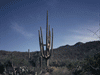
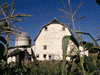
Introduction. I had canceled this trip six or eight times, most recently, three week earlier when our cat was dying. I was determined to finally complete this trip. Day One: The Scenic Route My wife had just begun a new semester of tutoring, so she passed. It was just Isabel (my Mustang), Robinson Crusoe (audio book), and me. We departed a little after 7 am heading north on Highway 14. I had to remember to make a right turn in Mojave to stay on Highway 14, as continuing straight would have taken me to Bakersfield. Just south of Mojave is a solar farm and to the west is a wind farm. I drove north through the Mojave Desert surrounded by Joshua Trees and a lot of open space. Highway 14 passes through Red Rock Canyon State Park which I have seen before, so onward I sailed. Eventually, Highway 14 ends at Highway 395 which starts about 100 miles south near Victorville. That is the only section of Highway 395 in California that I have not driven. Highway 395 passes Little Lake which extends east from the highway and Fossil Falls which I had visited before. This is about where Highway 190 heads east to Death Valley. I stopped at Coso Junction Safety Rest Area after two hours of driving. To the east of the highway is Owans Lake. This was once a large lake before water diversions, now it is mostly dry. I passed the turn off to Cottonwood Creek Charcoal Kilns which are on the west shore of the lake. I had visited these several years earlier, so I kept plunging north. Highway 395 passes through many small towns of the Owans Valley. Lone Pine is one of the significant towns that the highway intersects. There is a very well done Visitor Center which we visited shortly after it opened some time ago. We once spent some time at the wonderful Film Museum on the west side of the highway. Also on that visit, we drove through the Alabama Hills which lie just west of town and have been used in many movies, TV shows, commercials, and other projects. Most of Highway 395 from Highway 14 to almost the state line is a scenic byway with the eastern Sierra Nevada Mountains to the west and other mountain ranges to the east. Highway 395 slowly climbs as it travels north. It is hard to believe as you climb over a mile in elevation while traveling on what looks like a flat road. The highway is about 7,881 feet near Mamoth Lakes and peaks at 8,143 feet at Conway Summit a little beyond Mono Lake. A few miles north, on the west side of the highway is Manzanar National Historic Site where, during World War II, many Japanese-American citizens were detained. Today there is a visitor center, the cemetery, guard towers, driving tour locating important locations, and maybe the barracks have been recreated since our last visit. A few more miles brought me to Independence which is home to the East California Museum. We had visited this museum twice before and I am impressed with the quality of this small museum in a small town with indoor and outdoor exhibits. Be sure to see the coyote dentures. Continuing north, Highway 395 cuts through Big Pine and continues north to Bishop. Bishop is possibly the largest town along this highway and is home to the fairgrounds. Just outside town is Laws Railroad Museum and Historical Site. This is a collection of railroad equipment and structures and other historic structures filled with artifacts. Laws is a very well done museum which we visited on an earlier trip. I got gas in Bishop and continued north. I stretched my legs at the overlook for Crowley Lake on the east side of the highway. I flew past the turnoff for Devils Postpile National Monument which we had seen on an earlier trip, and then Mammoth which is a popular winter and summer vacation spot. I skipped the rest area at Crestview and continued. The desert started to give way to conifer trees. I wanted to take the June Lake Loop which is suppose to be quite scenic, but I missed the turn. Next came Mono Lake and Lee Vining. We have been to Mono Lake several times including spending a night in Lee Vining. I stopped at the Visitor Center which was new after our first visit to the lake. There are many things to do here including Tufa Towers, Mono Craters, the Upside Down House, and Highway 120 travels west into the northern areas of Yosemite National Park. There is one section of the highway that is squeezed in between the mountains and the lake and is subject to landslides. I got through and as I climbed out of the Mono Basin, there are some great overlook views of the lake. It wasn't long to the road to Bodie State Historic Site. Bodie is one of the best preserved mining / ghost towns. But maybe preserved isn't the best word, the park likes to call it "arrested decay." They aren't restoring the town, they are just trying to slow the natural decay. We visited Bodie twice before, but time was short, on onward I traveled. I passed Virginia Creak Settlement, owned by my Brother-in Law's nephew. We had a wonderful dinner here once. A few minutes later I drove though Bridgeport, a nice little town. As I continued north, I enters a pastoral valley. Highway 395 continues north past Topaz Lake and crosses into Nevada. I stopped to take a quick photo of the Nevada sign. The highway continues north through Gardnerville, Carson City (state capital), and into Reno. I found my hotel, checked in, unpacked, and left for my only real visit for the day. I found Fleischmann Planetarium at the University of Nevada, Reno easily enough. I began with the exhibits with a number of interactive exhibits and also several displays of space seen in popular culture (models, props, and photographs from many sci-fi and space media). At 6:00, I lined up for the planetarium show about the Moon. After, I finished the exhibits. I found my way back to the hotel and finished my evening. Day Two: Good and Bad. I got to bed late the night before and didn't sleep well. Fortunately, I didn't need to drive 450 miles that day. I got ready, ate a little, and left for church. After church, I finished loading and checked out. I headed north on Highway 395 back into California to State Highway 70, then turned west. I had recently read of a resort worth seeing, but on seeing it, I wasn't interested, so I turned around without stopping. Fortunately, on the way, I had noticed a sign for a railroad museum in Portrola. I spent an hour and a half at Western Pacific Railroad Museum. Most railroad museums that I visit concentrate on locomotives, but this has freight cars, work cars, Vistadome passenger cars, and other unusual equipment. I talked a while with a woman who's son was interested in trains and was exploring everything. I made a quick stop at Lester T. Davis Roadside Rest Area along State highway 70. At Vinton, I photographed the north most end of Highway 49, the only section that I hadn't yet driven. The first ten or twenty miles are pasture like, then give way to cliffs and trees. I passed through several small towns that seem like nice places to live. Eventually, I reached Downieville, the furthest north section of Highway 49 that I had previously driven, completing my total drive, in multiple sections over many years in various directions. Downieville is a nice little town, filled with tourists, squeezed into a narrow canyon. Two narrow bridges cross the river, one is Highway 49, the way I came, the other leads to the Courthouse and other structures. Most of the businesses are on Main Street on the north side of the river. Part of Main Street is Highway 49. There is a small History Museum, but not the one I remember being closed those 15 or 30 years earlier. I spent a little time walking Main Street, then continued south the way I did all those years ago. I then drove to Nevada City where I got gas and then began searching for Bridgeport Covered Bridge in South Yuba River State Park. I drove back looking for Sweetland which I couldn't find. I stopped beside a business and tried to get my phone to cooperate. When it finally told me where I was, I was in Sweetland, so I took the adjacent road west. Along the way I found an old Wells Fargo building and photographed it. It is a little controversial as some think it was never really a Wells Fargo building, but it looked like one to me. As I continued, the road got more narrow and winding. It didn't seem like the way to a state park, so I returned to Highway 47 and headed toward Grass Valley. Finally my phone decided to work again and told me to turn right onto Birchville Road. This was another narrow and winding road but eventually reached Pleasant Valley Road where I turned left. After a few minutes it looked familiar, or was that a different heard of goats? Then the same Wells Fargo building. I turned around and drove back to Sweetland. I again drove south on Highway 49, this time, the rest of the way to my hotel in Grass Valley. I was pretty frustrated by the time I checked into my room. The day had started well, the resort was a disappointment but the railroad museum was enjoyed. I wasn't able to find the museum in Downieville that I remembered seeing from the outside twenty years earlier, but liked Downieville in general. I did want to see the Wells Fargo building in French Correl. The covered bridge, a top priority, was too hard to find. Day Three, Timbuctoo and More I arose early, but got more sleep than the night before. It was two hours before breakfast, so I got caught up with things. I was off on my day before 7:00, which is fine because my first several visits don't have hours. I wandered historic Grass Valley for a short while and photographed many old buildings, including the Holbrooke Hotel, the oldest continuously operating hotel in California, at least that is the story. I walked a pedestrian street lined with shops and restaurants, but none were open yet. From here, I drove west to the southern section of Pleasant Valley Road, which finally brought me to Bridgeport Covered Bridge and South Yuba River State Park. No one was there when I arrived and it would be two more hours before the visitor Center opened. I photographed the bridge, walked through it, walked around to the river shore to look up at it, and photographed the barn and gas station. By this time, a ranger had opened the barn and gas station and was raising the flag, so we talked a few minutes. I then photographed the interior of the barn filled with wagons and equipment and the gas station with dioramas and other exhibits. From here, I had two more quick stops in Yuba County, one of only four California counties I had not yet visited. It was only a few minutes to Smatrsville, a very small community that recently solved a big problem. The Postal Service insisted on calling it "Smartville" and the town fought hard to put the "S" back in the middle. I photographed a Catholic church that has been closed and they are trying to protect it, an old store, and the Post Office that now says "Smatrsville." It was only a short distance to Timbuctoo, off a very narrow road, There isn't much left, two or three deteriorated building behind a barbed wire fence. I photographed what I could and returned to my hotel. By now, Nevada County Narrow Gauge Railroad Museum was open, so off I went. It took about five minutes to reach this museum that is unusual in emphasizing railroads with a track width narrower than standard. I wandered about an hour and returned to my room for a short break, then off for another destination. I had one last goal for today and the third of my three priorities. I headed east on California State Highway 20. It was a tree lined route and relaxing. There was a construction area with one lane open and a flag system controlling the two-way traffic on one lane. There were only six vehicles waiting ahead of me and dozens behind. I waited a half hour, if I had come through a minute or two sooner, there would have been no wait. Then I didn't see any construction. Eventually, Highway 20 merged with I-80. There was more construction here, but we were slowed, not stopped. Finally, I arrived at Donner Memorial State Park. After checking it, I walked the short distance to the memorial, a three-figure statue on a stone pedestal the height of the snow in Donner Pass that fateful winter of 1846, 22 feet. A short walk brought me to a large bolder that was one wall of one of the three cabins. Next, I drove Donner Pass Road to the top of Donner Summit at 7,135 feet. From the top of this drive it affords a view back to the lake and also the historic road bed of the Central Pacific Railroad, part of the first transcontinental railroad, including tunnels. The road continues many more miles beyound where I turned around which was a large parking lot. I was wondering what the large building was, then notice towers and cables for a ski lift system. I returned to the Visitor Center and watched the video and used the restroom before heading back to Grass Valley. Fortunately, the return was not effected by construction and I arrived back at my room about 6:00 and settled in for the evening. Day Four: I arose, got ready, ate, packed, and got gone. I departed about 7:00 AM. Originally I had planned to stop at Smartsville and Timbuctoo today, but I did those the day before, so I pressed west to Marysville. I knew that Mary Aaron Memorial Museum would be closed, but I couldn't find much in Yuba County, so I photographed the exterior of the museum and moved on. I stumbled upon an equestrian statue and decided to see it. "The King of the Cowboys" by Cotton Rosser sites at a corner in Marysville. It was only a few miles to the Sutter County Museum in Sutter County, another of the counties I had not yet visited. Unfortunately this museum is closed Monday and Tuesday and this was Tuesday. Again, I photographed the exterior and a few outdoor exhibits and moved on. About twenty minutes south I reached Bobelaine Audubon Sanctuary at the end of a narrow farm road. The facilities were minimal with a porta potty and an information kiosk. A map showed extensive trails on the other side of the levee, but after walking a distance in both directions, I didn't see a good way down. I photographed a few water fowl from a distance and left. It wasn't long until I was driving south on I-5. The first two rest areas were closed but finally at Coalinga-Avenal Rest Area, I was able to take a short nap and use the restroom. I got gas near Taft Highway. For much of the Central Valley, you can't see the mountains on both sides at once, so it's always a good feeling as you approach the southern end you can see mountains ahead and on both sides. I stopped at the Tejon Pass Rest Area near Lebec and continued on, arriving home about 4:20 pm. My cats and dogs were glad to have me home. |

|

|

|
| Note:This is not the official site for any of the places shown in Places Earth. Places Earth is not responsible for accuracy of the information. Hours of operations, prices, exhibits, and sometimes locations are subject to change without notice. |
|
Links |

|
This site maintained by Kenneth A. Larson. Copyright © 2004 - 2023, Kenneth A. Larson. All Rights Reserved. Website content including photographic and graphic images may not be redistributed for use on another website. |

|

|

|