Places, Earth
Northern California, 2025
Northern California, 2025
|
|
Places, Earth
Northern California, 2025 |
|
|
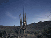
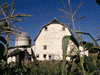
Day One, A Fort and a Capitol For several years, we had been thinking of attending the Pear Fair in Courtland and see Northern California. Since Lassen National Park is snowy until July and I'm usually unable to get away during the summer, we kept putting it off. Since I had a temporary eye issue making if difficult for me to do my computer drafting and modeling job, and my wife learned that there would be no summer tutoring, we decided this was the summer for which we had been waiting. Originally we had planned to do a simple weekend to Sacramento and the Pear Fair on the way home. Since we had the time and we would already be in Sacramento, we added another five nights and did the rest of the trip. We left a little after 8:30 AM, later than we usually start, and headed north on Highway 99. We played Sons of the San Joaquin as we drove north through the San Joaquin Valley. We encountered heavy traffic in Stockton, but eventually arrived at Sutter's Fort State Park. John Sutter owned this trading post and it was here that the gold discovery was first documented. Today the restored complex is open for visitors. We wandered through the buildings and exhibits about an hour. The fort is a rectangle with shops making up the inner side of the walls with a two-story building in the center which seems to have been John's office and bedroom. It wasn't far to the state capitol, but it was hard to park. I wanted to see the grounds, which we missed many years earlier, but construction of a new annex made it difficult. With difficulty, I walked around the building, often from across the street. From here we drove to our hotel and settled in for the night. Day Two: Delta Day We arose early, got ready, and ate breakfast. My wife got some rest while I attended Mass. We packed up, checked out, and headed for the Pear Fair. It only took a half hour to find the Pear Fair in Courtland in the Sacramento River Delta. My wife asked what a levee was and I told her that we were driving on one (I drove my Mercury to the levee, but the levee was dry [on one side]). The river was just a few feet to the right. We wandered the festival a few hours. We learned about the Delta Tunnel (the group opposed it) and the history of the Delta. We listened to music and a duck calling contest. We bought a whole pear pie, two slices, a big bag of pears, and two 3-cheese grilled cheese sandwiches. There were the usual merchandise booths, information booths, and a food court. I bought a pear cook book. It was fun, but we left before the parade. I had long wanted to visit Locke, a town settled by a Chinese community. It was only about eight miles downriver from Courtland and we continued south along the top of the levee. The once primarily Chinese community is now about 80 people, most are not Chinese. We visited the Boarding House Museum which was filled with exhibits, then walked down one side of Main Street and back along the other side. Along the way were several small museums such as the Schoolhouse, and a gambling hall. Main Street is a historic district and a time capsule. On the way back to Interstate 5, we photographed a few pear trees in one of the many orchards in the Delta. Pears like cool weather which can be found in the Delta with a clear path to the Pacific Ocean. From Locke, we headed back north through Sacramento, along a section of Highway 99 that I had never driven before, and arrived in Chico about 4:00 PM. We checked into our hotel, unpacked, and went grocery shopping. We spent the rest of the evening resting and enjoying dinner. Day Three: Bidwell-Red Bluff We arose, got ready, ate, and left for Bidwell Park, one of the largest city parks in the country. We first stopped at North Park at a playground and picnic area and then walked the Trail of Giants, a collection of mature oak trees. A small area was fenced off and filled with grass mowers, AKA goats. We then drove further into the park. My wife didn't want to do a lot of walking and then another visitor told us about Honey Run Covered Bridge. We left the park and drove to Honey Run Covered Bridge. The bridge had been destroyed in the Paradise Fire and recently rebuilt. It wouldn't open for another fifteen minutes (9:00 am) and we were able to see it from outside the gate, so we moved on. The town of Paradise, which was famously destroyed in the same fire, was only six miles on, but we decided to pass since the only reason to visit was to see this disaster site. We returned to the hotel and checked out. We headed north on Highway 99 and stopped a few minutes to photograph the outside of the closed Tahama County Museum. It wasn't far along Highway 99 to Red Bluff along I-5. We spent an hour at Gaumer's Mineral and Mining Museum which is also a rock, gem, and jewelry store. We got a sub sandwich for lunch and fed gas to our car. It wasn't far to William B. Ide Adobe State Historic Park. It was originally named for William B. Ide, the only president of the Republic of California. The republic lasted only a short time before California joined the United State. Recent research has concluded that he actually never owned or lived in the adobe. It is not a large park and the Visitor Center wasn't open (closed Monday and Tuesday). We ate our sub sandwiches at a table in the shade, wandered around the adobe, and moved on. We knew that Kelly-Griggs House Museum wasn't open, but drove by to take a photograph anyway. It took a little over an hour to drive from Red Bluff to Chester. We easily found the hotel, checked in, unpacked, and left for a drive around Almanor Lake. We found a few good spots to pull off the road for photos. It should have taken an hour, but road maintenance on the West side with only one lane open and direction control, added another 15 or 20 minutes. Once back, we walked a short distance to Bing's Lake Almanor Bistro, which is a mix of Japanese, Chinese, and American. We settled in for the night. Day Four: Volcanos and Caverns We got ready, I drove across the road for gas, we enjoyed our breakfast (a little better than the previous town), checked out, and headed back the way we came the day before. It was still early when we entered Lassen Volcano National Park. The Visitor Center wasn't open yet so we drove in a short distance and came back. We stopped at Sulfur Works to observe the bubbling mud pots. The smell of Hydrogen Sulfide was hard to ignore. Back at the now open Visitor Center, we got some useful information and re-entered the park. Most of the hikes were longer than we wished to take, so we saw what we could near the car and continued. At the Manzanita Lake Visitor Center, we met a couple with a Yorkie dog with the same middle name as my wife's Yorkie, and chatted a bit. We were ahead of expectation so we checked in to the hotel (first check-in for the day), unpacked, and left for Lake Shasta Caverns. The Caverns are only about 20 miles north of Redding and we were there a half hour early and bumped to an earlier tour. People told us that the tour begins with a boat ride across the lake and a bus up the hill, then the first part of the tour is easy and you have the option to skip the harder part. What we found was a hard down hill walk and the first part of the tour was just as hard as the second half. My wife skipped the entire cave tour, but fortunately, they allowed a courtesy vehicle to take her up the final hill. I enjoyed the full tour. We returned to Redding, bought some frozen meals from Trader Joe's, enjoyed our dinner, topped with slices of the pear pie we bought a few days earlier. Day Five: Museums and Waterfalls We got off about 8:00 AM heading north on I-5. We exited to see waterfall which was suppose to be easy. We drove some distance and the further we drove, the worse the road. Finally the Maps on the phone took us up a road not fit for a station wagon. With a mile left, I backed up until I could turn around. The phone now told me that the waterfall was over an hour away, so we just gave up and returned to Interstate 5. About 200 feet from the asphalt, we hit a large deep pothole with such force, I inspected the underside of the car before proceeding. We continued on to Weed. In Weed, we got gas and found Weed Historic Lumber Town Museum. The building is a former courthouse, jail, and other municipal services. The building is packed with artifacts including photos, tools, equipment, a stage coach, two fire trucks, household items, photography equipment and theater projector. We spent over an hour and the volunteer gave us a lot of information. We really enjoyed the visit. Next we drove east to the former lumber town of McCloud. Here we spent another interesting hour at the McCloud Heritage Junction Museum. Like the previous museum, this was filled with artifacts such as medical, a scary looking hair drier, tools, household items, logging exhibits, and typewriters. We crossed back across the highway and a mile on we stopped at Bogey's Café beside a golf course. I had a Cobb Salad and my wife enjoyed a Chicken Club Sandwich. We enjoyed our lunch. From here, we continued east into Shasta Trinity National Forest. We turned right at McCloud Waterfalls loop. All three of these waterfalls are accessible with extended trails to the base. The first we found was Lower Falls which is a popular diving site. I am told that the water is very cold. Next, as we continued the loop, we came to Middle Falls. My wife stayed at the upper observation point, I walked down the trail part way to get a better view because you really can't see it well from the observation point. Next was Upper Falls. Again, my wife stayed at the upper observation point as I walked down the trail part way to get a better view. We continued on to Burney Falls. We missed the sign and had to backtrack about 15 minutes to McArthur-Burney Falls Memorial State Park. The waterfall is beautiful from the top, but better from below. There is a .3 mile trail to the bottom and a 1.2 mile loop. I walked down about .2 miles and back up while my wife waited at the top. Roosevelt Called it the 8th Wonder of the World. In addition to the water falling over the edge, numerous falls begin in the face from ground water. From here, it was about an hour and a half back to Redding where we enjoyed a quiet evening. Day Six: Joss House and Turtles We got off early heading west. The highway passed through the town of Shasta and Shasta State Historic Park, which is a collection of brick ruins. The park wasn't yet open, but I was still able to photograph many of the building, most are unsafe and supported with steal beams and braces. We stopped at the Whiskeytown Visitor Center which wasn't open, but we used the restrooms. Whiskeytown, what is left, is now under the reservoir We continued on. We waited about 15 minutes at another one-lane escorted road construction. Several miles of road was being resurfaced. We arrived at Weaverville Joss House State Historic Park about 9:00 AM. The web site said the park opened at 9 and the Joss House at 10. Actually the park opens at 10 and the first tour (the only way to see the interior) is at 11. So, we waited a while. The first hour, I wandered through the adjacent museum, with which the indoor was still closed, but the outdoor area was open. And I drifted up Main Street and photographed some building including the Courthouse. The second hour we chatted with the staff. At 11:00 AM, the tour began. We crossed over a bridge with an arch, because evil spirits do follow straight lines and are confused by curves. The Joss House sits on the original location were it was built in 1874 as a replacement for an earlier building that was destroyed by fire. Its name is also “Temple Among the Forest Beneath the Clouds.” It is the oldest continuously used Chines temple in California. Because evil spirits only move in straight and level paths, the door, on a high threshold, is kept closed and humans go around while the evil spirits can't. Since evil spirits like order, butterflies and bats, which fly erratically, challenge order. Icons of butterflies fill the temple and stylized images of 108 bats cover many surfaces. Colors are symbolic, red is good luck, orange is for wealth, green is for health. Four banners, representing the seasons, each contain 108 mirrors because mirrors represent truth. Every surface of the temple interior is filled imagery. Every object has meaning. Every image has meaning. From here, we returned to Redding, stopping for a sub sandwich on the way to Turtle Bay Exploration Park. We enjoyed the indoor exhibits, but there was more to see outside. It was quite warm and we dragged ourselves through the outdoor exhibits and back inside were it was cooler. One outdoor exhibit that I found interesting was a Shay locomotive with a surprisingly small boiler. My wife waited as I walked across the Sundial Bridge to the Arboretum. Again, it was a little warm, so I wandered about half of the large gardens and walk back across the bridge to collect my wife. These were two loose ends from a previous visit when we arrived after closing and only saw the bridge. We then had a modest drive back to Sacramento where we stayed the night in the same hotel where we started. What was left of the evening, we spent quietly in our room. Day Seven: Home We packed quickly and left a little after 6:00 AM, heading south first on Highway 99, then crossing to Interstate 5 at Stockton. We exited at Santa Nella, got gas, and arrived for breakfast at the only remaining Pea Soup Andersen's (sad) a few minutes before opening at 8:00 AM. I ordered a Veggie Omelette and my wife ordered Huevos Rancheros, and a small bowl of their famous pea soup for each of us. We had enough gas to get home and only stopped twice for rest areas. We arrived home at 1:30 and were greeted by our pets (and a mess). We managed to have one quarter of a pear pie by the time we arrived home. This leaves me with only four California counties left to visit. Time to start planning the next trip. |

|

|

|
| Note:This is not the official site for any of the places shown in Places Earth. Places Earth is not responsible for accuracy of the information. Hours of operations, prices, exhibits, and sometimes locations are subject to change without notice. |
|
Links |

|
This site maintained by Kenneth A. Larson. Copyright © 2004 - 2023, Kenneth A. Larson. All Rights Reserved. Website content including photographic and graphic images may not be redistributed for use on another website. |

|

|

|